Walking in Waterville
Situated as it is between the sea shore and the majestic mountains, Waterville offers many interesting routes for strolling, walking or serious hill climbing.
The following are some suggested routes for walking. The more adventurous visitor will find, of course, that these will only whet the appetite.
Waterville – Golf Links - Waterville
Leaving Waterville Village follow the road to the left at Dooley's Restaurant. This brings you along the cliff road. It is a very spectacular, pleasant walk on a fine summer’s day. You have a view of the whole of Ballinskelligs Bay and Carraig Eanna, a reef of rocks less than a mile from the shore. Continue to the end of the road until you come to the Inny Beach, a long sandy beach alongside the Golf Course
Return Distance – 2 Miles
Waterville – Waterlily Bay – Waterville
Leave Waterville Village, heading south. Pass a bridge and turn left at signpost for Hogs Head Lodge. Pass the lodge on your left and a woods on your right. This woods (Ballybrack Wood) is one of four few remaining native woods in Ireland, and reminds us of what the whole area was like in a previous age. Continue walking, with the lake on your left. You can see some of the lakes, Rabbit Island, Oven Island and the historic Church Island. At Waterlily Bay the road runs alongside the lake. You can walk along the shore and in season you can see an impressive display of water lilies in bloom. You may even be lucky and see a trout being hauled in!
Return Distance – 5 Miles

Waterville – Baslicon – Waterville
Using Waterville as a starting point, head towards Caherdaniel. Continue for about 1.25 miles until you pass a bridge on a dangerous right hand bend. After another 200 yards (approx.) turn right on to an old green road. The green road which is walled on both sides by beautifully built dry stone walls, continue for about .75 of a mile. You will be able to see across Ballinskelligs Bay and Lough Currane. When the green road crosses a tarred road turn right and continue past a bridge until you again meet the Waterville/Caherdaniel road. Turn left here and return to Waterville. Return Distance – 3 Miles

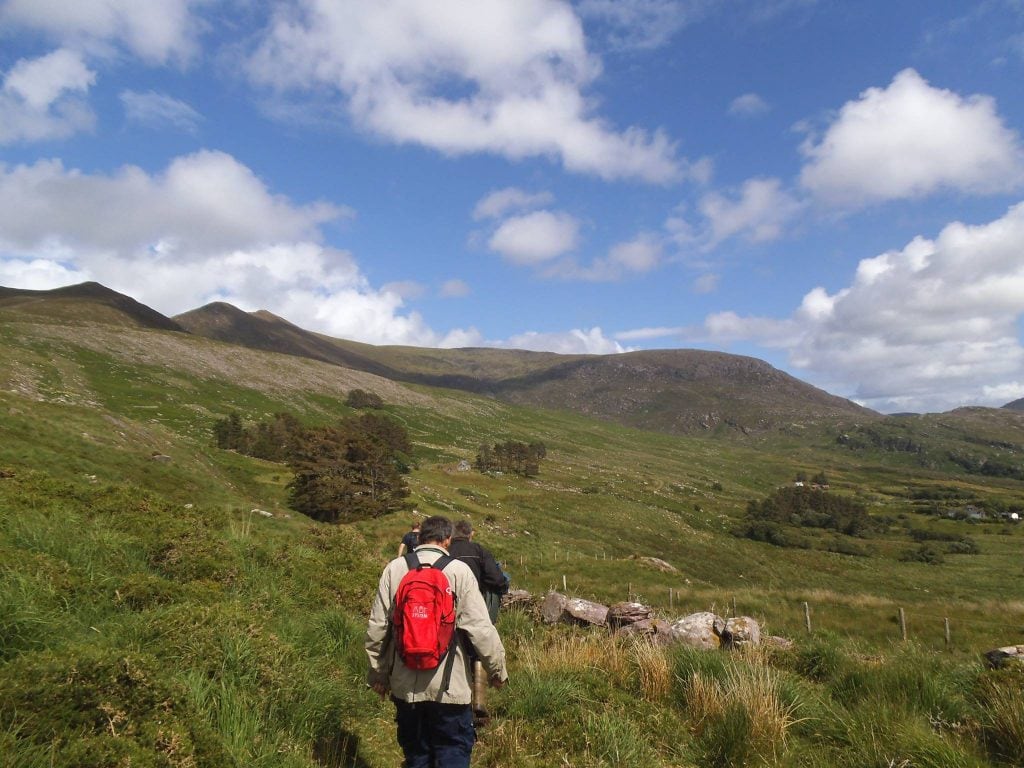
Waterville – Hogs Head - Waterville
Leave Waterville heading towards Caherdaniel. Turn right at a Petrol Station about 0.25 miles beyond the village. After about 1 mile you will be walking within sight of Ballinskelligs Bay. About 3.5 miles from Waterville you pass a small pier (Rineen Pier) used by the local fishermen. The road continues alongside the Bay and climbs through a gap in the mountain. On the other side you will see Derrynane Bay dotted by Scariff and Deenish islands. pass through this mountain gap, and you can see, standing stark and impressive on top of the mountain on your left, a bleak ruin of a building which is locally known as “the lighthouse”. It is in fact a military barracks, which served as a lookout station during the Napoleonic Wars. A similar structure can be seen, across the bay on Bolus Head. The road ends about half a mile from the mountain pass.
Return Distance – 9 Miles

The Kerry Way Cahersiveen - Waterville
Distance: 30km Time to Allow: 9 hours
Rejoining the Kerry Way at Teeraha, the trail leads up along a ridge of small hills just over the 200m mark. Gradually traveling back inland to the south-east, the Kerry Way crosses a main road and up to some higher peaks over 300 metres; Keelnagore at 329m, Knockavahaun at 371m and then finally descending to a lower peak at Canuig at 261m.
Rejoining a network of minor roads, the Kerry Way makes its way through the tiny hamlet of Mastergeehy, heading up a track behind the post office and on towards Coomduff.
At this point the Kerry Way once again splits into two. Seven kilometres to the south-west is the end of the stage at Waterville, where there is a selection of accommodation to choose from. A coastal section of the Kerry Way sees this stretch meet up again at a later stage with the other fork outside Caherdaniel.
The other option means trekking for a further 17km before meeting back up with the coastal detour. There is no accommodation to be secured over this period which would suggest that this should be tackled as a stage in itself.

The Kerry Way Waterville - Caherdaniel
There are two options for this section of the Kerry Way. The first is to follow the trail south from Waterville, this is the more low-lying option with views out to the Atlantic. The second option is the more demanding both in distance and height as it heads inland and through more remote settings.
OPTION A Distance: 11km Time to Allow: 3.5 hours
This first option makes for an easier pace with a lot less ground to cover. Heading south from Waterville the Kerry Way follows a small back road that gently rises up above the bay and provides beautiful views out to sea. After meeting the first T- junction the trail starts to head more inland, uphill and back towards the main road. After leaving the tarmac road, the Kerry Way then follows the old Kenmare Road and eventually crosses its more recent replacement. Rounding the base of Farraniaragh Mountain, the path comes across a megalithic tomb, which marks the highest point of the days climb at 248 metres above sea- level.
The Kerry Way crosses the main road again and starts to head downhill across fields and boreens, gradually easing its way into Caherdaniel.
OPTION B Distance: 26km Time to Allow: 8.5 hours
Being the tougher option of the two, the Kerry Way retraces 7km of yesterdays ground before reaching the fork in the trail. Heading southwards from the split at Coomduff, the trail is interspersed with sections on tarmac followed by wild mountain terrain.
Rounding the base of some unnamed peaks attached to Coomcallee and skirting Lough Currane below to the west, a height of 170m is crossed before the Kerry Way comes back down to the valley floor and then swings round to an easterly direction, crossing the north face of Eagles Hill and turning again, striking straight up to Windy Gap, a saddle just below the summit. This sees the highest point reached on the Kerry Way at just over 450 metres above sea-level. The final leg for the stage leads more gradually downwards to the quiet village of Caherdaniel.


Loop Walks in Waterville
Derriana Route (Compliments of Comhchoiste Ghaeltacht Uibh Rathaigh)
Start / Finish Location: Killenleigh Cross (Loop Walk)
Suitable for: All Walkers
Nearest Village: Killenleigh / Waterville
Footwear: Walking Boots
Distance:
13km (15km including Coomavoher Spur)
Description
Having parked safely in Killenleigh, walk in a southerly direction to Coiscumerach (sometimes called Crois a' Chárta as it once was the location of a forge). Turn left here and with the well kept grotto at your right, continue on along the ain road for about 1 kilometre.
The Cumerach River flows parallel to the road on the right hand side and hatchery has recently been reopened on this stretch of river to provide fish stocks for rejuvenation of local rivers and lakes. At the sign for Derriana Lake, you may choose to divert for a while along a windy cul de sac road as far as the town land of Coomavoher.
The views of the unspoiled landscape, lake and mountain from there are worth the effort. This road is narrow and has many blind spots and turns, so please take the utmost care when walking aling here. From the diversion point at Derriana Cross, continue along the main road once again, with the old school building on your left hand side.
This route is kown locally as “Cumergleann” and from its highest point you will have a great opportunity to see a vast stretch of the Inny Valley before entering a more secluded afforested area. At the next junction, turn left to return to your starting point in Killenleigh.
Slí Chois Cumeragh / Máistir Gaoithe Route (Compliments of Comhchoiste Ghaeltacht Uibh Rathaigh)
Start / Finish Location: Killenleigh Cross (Loop Walk)
Suitable for:
Semi Experienced Walkers
Nearest Village: Killenleigh / Waterville
Footwear: Walking Boots
Distance: 12.1km
Description:
Having parked safely at Killenliath, walk in a northerly direction over Killenliath bridge and take the first left turning marked with the red arrow.
On reaching the T junction at the end of this road turn left, crossing over the inny once more at Foildrenagh before you turn right onto the main road.
Continue on ahead, past the old Mastergeehy National School on your left hand side. This local landmark built in the nineteenth century, has been unused since the amalgamation of the 5 national schools in the parishin 1973
Continue along this route for about 0.5 km and turn left, taking the inclining road past the old church. From the elevated vantge point `long this route, one has
majestic views of the whole countryside, stretching for many kilometres featuring the river and mountains inland.
At the end of this uphill stretch, you will turn left and immediately you take a left again at the grotto at Cois Cumerach. Continue along this road to return to your starting point at Killenleigh.
Barr na hAoine Route (Compliments of Comhchoiste Ghaeltacht Uibh Rathaigh)
Start / Finish Location: Killenleigh Cross (Loop Walk)
Suitable for: All Walkers
Nearest Village: Killenleigh / Waterville
Footwear: Walking Boots
Distance: 12.5km
Description:
Having parked safely at Killenleigh set off northwards in the direction of Cahersiveen. Walk for 1km until you reach a crossroads where you will turn right. Continue on this tree lined route for a further 4km until you come to a T Junction known locally as Doire Cross where again you will turn right
Continue straight on and through Cashlagh Cross. On your right hand side at this point you will see Cashlagh Bridge a little way on your right hand side hust beside the Old School Building. Often referred to locally as “The Bridge of the School” this was a favoured haunt of Charlie Chaplin who often fished in the area.
Having gone straight through Cashlagh Cross, continue on to the next junction where you will turn right immediately crossing over the Inny River at Lissatunnig Bridge.
Continue on this roadway to complete the loop walk back to Killenleigh.
Just as you enter the village of Killenleigh note the standing stone of Liath Derg in a field on your right, who gave Killenleigh or Cillín Liath in Irish it's name.
While the first stretch of this walk offers an area of solitude, the upper part of the loop offers amazing scenes of rolling fields, mountains and river.
Hogs Head Route (Compliments of Comhchoiste Ghaeltacht Uibh Rathaigh)
Start / Finish Location: Ardcaorach (Loop Walk)
Suitable for: All Walkers
Nearest Village: Waterville
Footwear: Walking Boots
Distance: 9km
Description
This coastal walk stretches just over 9 km and combines wonderful scenic views and archaeology. Leaving Ardcaorach head south in the direction of the sea, taking the first turn left and following the natural curve of the road down towards the sea. On your way a visit to the 9th Century Loher Fort is particularly recommended.
At the T junction take a left for Reeneragh, observing the tide as it laps the shore in the near distance. The historical Skellig Islands are clearly visible from this vantage point, as well as Bolus across the bay.
On your return to the T junction contiue straight through to complete a loop walk, taking a right turn ultimately to bring you back to your starting point.
Glenmore Route (Compliments of Comhchoiste Ghaeltacht Uibh Rathaigh)
Start / Finish Location: Waterville, Southern Cross
Suitable for:
All Walkers
Nearest Village: Waterville
Footwear: Walking Boots
Distance: 8.8km
Description:
On this unique walk the road meanders in line with the lake shore and takes you along the edge of the world famous Loch Luíoch or Loch Coireán – Waterville Lake – widely known for its fresh water fishing for many generation. You will pass through numerous townlands with musical sounding names such as Inchfarranagleragh, Cappamore and Raheen on your way, passing the local landmark of Carraig a' Chucu on the way.
A visit to teach Bhríde, a museum and heritage centre in the former school building and run by the local community is a must before returning to your starting point. If time is a consideration, it might be a good idea to get a lift as far as Teach Bhríde and walk the route in one direction.
Emlagh Loop Walk
A-B. Starting from the mapboard on Inny Strand, follow the purple arrow along a wire fence in the direction of Inny Strand. After 30m pass a stile on your left – you will return to this point at the end of your walk. After 200m cross a small stream and continue to follow the strand for over 1.5km to reach a roadway at the entrance to Inny Estuary. Turn left here.
B-C. Follow the minor roadway for 500m to reach a T-junction with the main R567 - turn right and, almost immediately, turn left onto another minor roadway. Continue to follow the purple arrows along this roadway for over 1km to reach a junction with a track on your left. Turn left here.
C-D. Now the loop takes you along a track through an area of bog – it turns right after 200m and exits through forestry to reach a junction with a bog road. Turn left here. Continue to follow the bog road for 1.3km (crossing a number of stiles) to reach a point where the loop leaves the bog road and turns left through a metal gate. Cross a short section of bog to exit onto the R567. Turn right here.
D-A. Follow this surfaced road for approx 200m to reach a stile (and gateway) on your left. Cross the stile to join a farm roadway and enjoy the last 400m back to the trailhead.
Bolus Head Loop Walk Ballinskelligs
A-B. Starting from the trailhead, follow the purple arrow along the surfaced road for 1.5km to reach a Y-junction - the roadway to the left is a cul-de-sac. This is the point from where the loop ‘proper’ begins - you will return to this point later - for now veer right. Follow the road to a gate into a disused farmhouse. Cross the stile and proceed to the back of the house.
B-C. Behind the house the loop turns right and zig-zags along a line of dry ditches, crosses a stream, and starts an angular ascent onto the ridge from where you have superb views of the Skellig Rocks and the broad Atlantic! Turn left on the ridge - and be aware of the high cliffs on your right as you follow the purple arrows along the official track on the ascent to reach an old stone hut. From here the loop ascends again - this time along the left of a wire fence - to reach the ruins of a military barracks and lookout post. From the barracks the loop turns left.
C-D. Follow the purple arrows on the right of a wire fence as the loop decends gently to a pass at Ducalla and reaches a green road at a stile (on your left). Turn left here.
D-A. Follow the green road downhill into the townland of Ducalla. After 1km you rejoin the outward section at the Y-junction in B above. Turn right and enjoy the 1.5km back to the trailhead.
Lough Currane Loop Walk
This is a very long walk that is also demanding. Distance : 22.5km
Estimated Time : 8 hours
Features : Hilly
Difficulty : Hard
Maughernane Circuit – Waterville
This walk follows a pathless route to a summit of 675m. It involves a ridge but is not overly demanding with gentle climbs to the summit.